Category: Beaches & Nature

  • Central Park in New York: The Ultimate Guide to Visiting

    Central Park in New York: The Ultimate Guide to Visiting

    🇧🇷 POR | 🇫🇷 FR | 🇺🇸 EN | 🇪🇸 ES

    Central Park sits right in the middle of Manhattan, New York City, and is the most visited urban park in the United States, with free entry and open access every day. It occupies a rectangular strip between 59th and 110th Streets, bordered by the Upper West Side, Upper East Side, and Harlem, and is just a few minutes by subway from Times Square or 5th Avenue. The best time to visit is from April to October, when the trees are in bloom or showing off their fall colors, but the park operates year-round and doesn’t require any budget beyond what you want to spend on extra activities. What most people don’t know is that much of the “natural” look you see there was meticulously designed with rulers and compasses in the 19th century — and that history changes the way you walk through it.

    How to get there

    From the US, flights to New York land at JFK, Newark (EWR), or less frequently, LaGuardia (LGA). Major cities like Los Angeles, Chicago, and Miami have direct flights ranging from 3 to 6 hours with airlines like American, Delta, and United. From the airport to Manhattan, the most budget-friendly option is the AirTrain connected to the subway (JFK) or an express bus (Newark), with a travel time of 45 minutes to 1 hour 15 minutes depending on traffic; a taxi or rideshare costs significantly more and can take twice as long during peak hours.

    Once in the city, the park has subway stations on nearly every edge: the A, B, C, D, and 1 lines stop near the west entrance (Columbus Circle and surroundings), while the N, Q, R, and 4/5/6 lines serve the east side. There isn’t a single “main entrance” — the park has over 20 numbered gates along its perimeter, so it’s best to choose the access closest to the spot you want to visit first. Walking from one side of the park to the other (east-west) takes about 20 minutes; covering the entire length (south-north) can take over an hour on foot.

    Best time to visit & how long to stay

    “Can you see the whole park in an afternoon?” You can get a great first impression in 3 to 4 hours, covering the southern section, which has the most famous attractions. To explore it at a leisurely pace — including the Central Park Zoo, the Ramble, and the Reservoir — set aside a full day, preferably on a weekday when it’s less crowded. Spring (April to June) brings cherry blossoms near the Reservoir and mild temperatures; fall (September to November) is the most photographed season, with leaves changing color from mid-October to early November. Summer is hot and full of free events like SummerStage; winter empties the park, but there’s ice skating at Wollman Rink and, in heavy snow years, sledding on Pilgrim Hill.

    What to see in Central Park

    The park covers 341 hectares, according to the Central Park Conservancy, the non-profit organization that maintains the space, so no one can cover it all on foot in a single visit without a plan. The simplest approach is to start with the southern end, which is more concentrated with attractions, and head north as time allows.

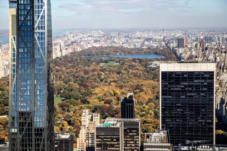
    Aerial view of Central Park in New York City during autumn
    The 341-hectare green rectangle cuts through Manhattan from east to west. | Photo: Louis / Pexels

    Bethesda Terrace and the Angel of the Waters Fountain

    This is the most photographed spot in the park, with an arched staircase leading down to a terrace by the lake, with the Angel of the Waters statue at the center of the fountain. It’s about a 15-minute walk from the 72nd Street entrance on the east side, and street musicians often play under the arch because of the acoustics.

    Bow Bridge

    A cast-iron arch bridge over the lake, just a few steps from Bethesda Terrace. It appears in dozens of movies and is the classic New York proposal spot — arrive before 9 a.m. if you want photos without people in the way.

    Bow Bridge, the most photographed cast-iron bridge in Central Park
    The Bow Bridge connects two shores of the lake and is one of the park’s postcard-perfect spots. | Photo: Artūras Kokorevas / Pexels

    Strawberry Fields

    A memorial to John Lennon, near the Dakota Building where he lived. The circular mosaic with the word “Imagine” is close to the 72nd Street West entrance and often has flowers left by visitors.

    Bethesda Fountain with the Angel of the Waters statue in Central Park
    The Bethesda Fountain is the classic meeting point in the heart of the park. | Photo: Marta Wave / Pexels

    The Ramble and the Reservoir

    The Ramble is a wooded area with winding trails, great for birdwatching — the park lies on the Atlantic flyway and hosts over 230 recorded species throughout the year. The Jacqueline Kennedy Onassis Reservoir, further north, has a 2.5-mile track used by runners and offers open views of the surrounding buildings.

    Central Park Zoo

    The zoo is inside the park itself, near 5th Avenue and 64th Street, with tickets starting at $22.95 for adults (check current prices and hours on the official Central Park Zoo website before you go, as they change frequently). Kids under 3 get in free. From April to October, it’s open from 10 a.m. to 5 p.m. on weekdays and until 5:30 p.m. on weekends; in winter, hours shrink to 10 a.m. to 4:30 p.m.

    Sea lion in the pool at the Central Park Zoo
    The sea lion pool is the most popular attraction at the park’s small zoo. | Photo: Miguel Cuenca / Pexels

    What to combine / nearby attractions

    The park borders some of Manhattan’s most visited spots, making it easy to combine outings on the same day. On the south side, exiting at Columbus Circle leads directly to the start of Times Square, about a 15-minute walk or two subway stops away. On the east side, 5th Avenue is home to museums like the Metropolitan Museum of Art, the Guggenheim, and the American Museum of Natural History, all with entrances from the park itself. Travelers passing through New York who are putting together a broader city itinerary often also include the Statue of Liberty, though it’s much further south on Liberty Island and requires a separate ferry trip.

    Where to eat

    Inside the park, options are food trucks and kiosks — pretzels, hot dogs, and ice cream, ranging from $5 to $10 per item, with higher prices near the busier entrances. For a sit-down meal with a lake view, the Loeb Boathouse has its own restaurant, but it’s pricey and requires a reservation. A more budget-friendly alternative is to exit through any gate and eat in the surrounding neighborhoods: the Upper West Side has classic delis and pizzerias for $12 to $20 a plate; the Upper East Side tends to be pricier. Packing a snack and having a picnic on Sheep Meadow, the open lawn at 66th Street, is common among New Yorkers on sunny days.

    Where to stay

    There’s no lodging inside the park, so choosing a neighborhood depends on your travel style. Staying near Columbus Circle or the Upper West Side puts you just minutes on foot from several entrances and close to the subway for the rest of the city — it’s the most balanced option between cost and location. Midtown, further south, is a longer walk from the park but has more hotel options across all price ranges, plus it’s near Times Square. Those looking for a quieter, more residential vibe often prefer the Upper East Side, which is pricier on average but has calmer streets at night.

    Practical tips

    It’s worth setting aside a full half-day if you enjoy walking and taking photos without rushing; for a quick stop in New York, you can see the essentials of the southern section in 2 to 3 hours. The most common mistake is trying to cross the entire park on foot without planning your route — the north-south distance is longer than it looks on the map, and many of the internal trails aren’t clearly marked for first-timers. Bring water and sunscreen even on cloudy days — there are few shaded spots on the open lawns, and the drinking fountains don’t always work outside of summer. For international visitors, a U.S. visa (B1/B2 or ESTA, depending on the type of trip) is usually required; always check the current rules on the official consulate website before booking your ticket, as they change. Regarding safety, the park is well-policed during the day, but avoid more isolated areas, like parts of the Ramble and North Woods, after the announced nighttime closing.

    Frequently asked questions

    What is in Central Park?

    The park features lakes, open lawns, wooded trails, a zoo, running tracks, an outdoor theater, an ice skating rink in winter, and historic spots like Bethesda Terrace, Bow Bridge, and Strawberry Fields, along with statues, playgrounds, and birdwatching areas.

    What is the most famous part of Central Park?

    Bethesda Terrace and Bow Bridge, both in the central-southern area of the park, are the most photographed spots and the easiest to recognize in movies and New York postcards.

    What is the history of Central Park?

    The park opened in 1858, designed by landscape architects Frederick Law Olmsted and Calvert Vaux, on land that previously housed working-class neighborhoods, including the African American community of Seneca Village, which was removed to make way for the project. It was the first major planned landscape park in the United States and became a model for urban parks in other cities across the country (more details on the Wikipedia page for Central Park).

    What to do in Central Park in New York?

    Walk to Bethesda Terrace and Bow Bridge, visit the Central Park Zoo, rent a rowboat on the lake, have a picnic on Sheep Meadow, run or walk around the Reservoir, and, depending on the season, catch free SummerStage performances or go ice skating at Wollman Rink.

    What movie was filmed in Central Park?

    Several. “Home Alone 2: Lost in New York,” “When Harry Met Sally,” and “Coming to America” all have scenes in the park, among dozens of other productions that have used the setting over the decades.

    Is Central Park the largest park in the world?

    No. At 341 hectares, it’s large for an urban park in the middle of a dense metropolis, but it’s far from the largest park in the world — it’s not even the largest park in New York City, a title that belongs to Pelham Bay Park in the Bronx.

  • Grand Canyon: The Ultimate Guide to Visiting in Arizona

    Grand Canyon: The Ultimate Guide to Visiting in Arizona

    🇧🇷 POR | 🇫🇷 FR | 🇺🇸 EN | 🇪🇸 ES

    The Grand Canyon is a gorge over 1,800 meters deep carved by the Colorado River in northern Arizona, USA. It’s about a 4-hour-20-minute drive from Las Vegas to the most visited side, the South Rim, or less than 2 hours if you’re heading to the canyon’s west side, which is closer to the city. Entry costs $35 per vehicle, valid for 7 consecutive days, and the best time to visit is from April to May or September to October, when the summer heat has passed and the winter roads haven’t closed yet. What surprises first-timers isn’t just the size—it’s discovering that much of this rock was once at the bottom of an ancient sea, long before any canyon existed (more details on the Wikipedia page for the Grand Canyon).

    How to get there

    There are no direct flights from Brazil to near the Grand Canyon—the most common route is to fly to Las Vegas or Phoenix, with a connection in cities like Miami, Atlanta, or Houston, totaling between 14 and 18 hours of travel depending on the layover. Always check the visa or ESTA rules for Brazilians on the official U.S. government website before buying your ticket, as requirements can change.

    From Las Vegas, the South Rim (the most visited area with the most infrastructure) is 280 miles (450 km) away, about a 4-hour-20-minute drive. Grand Canyon West, home to the Skywalk glass bridge, is much closer at 126 miles (203 km), about 2 hours and 20 minutes. If you don’t want to drive, you can opt for bus tours from Las Vegas, scenic plane flights (from $130, about 2 hours of travel), or helicopter tours, which are pricier, starting at $210. Renting a car is usually the most flexible option if you plan to stay more than a day in the area.

    Best time to visit and how long to stay

    “Is the Grand Canyon cold?” It depends on the season and which part you visit. The South Rim sits at over 2,100 meters in altitude, so winter brings snow and below-freezing temperatures at night, while the bottom of the canyon, near the Colorado River, can exceed 40°C in summer—the temperature difference between the rim and the bottom often exceeds 15°C on the same day. April, May, September, and October balance mild temperatures with fewer crowds than July and August, when the park sees its highest visitor numbers of the year.

    If you just want to see the main viewpoints on the South Rim, half a day covers the essentials. Setting aside a full day lets you hike short trails along the rim and catch the sunset, one of the most popular moments for photographers. Hiking down to the canyon floor and back in a single day is not recommended by the park itself—the trek involves a steep elevation change and usually requires an overnight stay, either camping or staying at Phantom Ranch on the riverbank.

    What to see at the Grand Canyon

    The national park is divided into the South Rim, North Rim, and Grand Canyon West—each managed differently, with its own attractions and infrastructure. Most international visitors choose the South Rim, which is open year-round and easier to access.

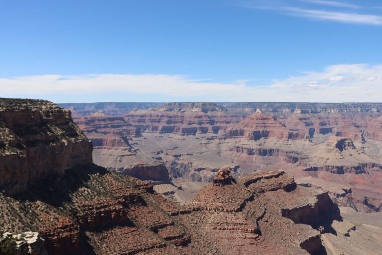
    Panoramic view of the Grand Canyon in Arizona
    The exposed rock layers in the canyon walls record nearly 2 billion years of geological history. | Photo: Lindsey Willard / Pexels

    South Rim viewpoints

    Mather Point, near the Visitor Center, is the busiest viewpoint and the first one most visitors see. Yavapai Point and Hopi Point, connected by a free park shuttle, offer wider views of the gorge and are popular for sunset.

    Rim and inner canyon trails

    The Rim Trail is a flat, easy-access path that connects several viewpoints along the edge, great for those short on time. For those wanting to descend, the Bright Angel Trail is the most traditional, but the National Park Service itself recommends against trying to go down and back up in the same day—the heat at the canyon floor is one of the main reasons for rescues in the park.

    Viewpoint on the South Rim of the Grand Canyon
    The South Rim is home to most of the viewpoints and visitor infrastructure. | Photo: LP Studio 90 / Pexels

    The Colorado River and the canyon floor

    At the bottom of the gorge flows the Colorado River, which carved the canyon over about 5 to 6 million years—far less time than the age of the rocks exposed in its walls, some of which are nearly 2 billion years old and formed when the region was covered by shallow seas, long before the age of dinosaurs. You can hike down to the river, ride a mule, or take rafting trips organized by authorized operators.

    Colorado River cutting through the Grand Canyon
    The Colorado River, at the bottom of the canyon, sculpted the landscape over millions of years. | Photo: Laszlo Magyar / Pexels

    Grand Canyon Skywalk

    Located on the West Rim, managed by the Hualapai Tribe, this is outside the boundaries of the federal national park—it charges its own entry fee, separate from the National Park Service fee. It’s a horseshoe-shaped glass platform suspended over the canyon and is often the most popular day trip for those staying in Las Vegas.

    What to combine / nearby attractions

    If you’re already in Arizona, it’s common to combine the Grand Canyon with other parks in the region, like Antelope Canyon and Horseshoe Bend near the town of Page, about 2.5 hours from the South Rim. For those planning a trip from Las Vegas, the visit often fits into a larger western U.S. road trip, linking casinos, the Hoover Dam, and, depending on time, bigger cities like Los Angeles—to organize this kind of longer itinerary, check out the complete Los Angeles guide from Voyage Voyage.

    Where to eat

    Inside the South Rim, Grand Canyon Village has a few restaurants connected to the park’s hotels, with dishes ranging from $15 to $30. The El Tovar Hotel, the most traditional in the area, has its own restaurant with higher prices and usually requires a reservation. For cheaper options, the town of Tusayan, about 10 minutes from the south entrance, has diners and pizzerias in the $10 to $20 range. Bringing water and snacks is essential if you plan to hike the trails—inside the canyon, water refill stations are limited and don’t always operate outside of peak season.

    Where to stay

    Staying inside the park at Grand Canyon Village puts you just a few minutes’ walk from the main viewpoints, but spots are limited and often book up months in advance, especially in summer. Tusayan, right at the south entrance, has more hotel options at slightly lower prices and is still just a few minutes’ drive from the gate. If you’re traveling from Las Vegas, you can also opt to do the trip in a single day without an overnight stay in Arizona, but you’ll miss the chance to see sunrise or sunset at the canyon, considered the best times for photos.

    Sunset over the Grand Canyon
    Sunset changes the colors of the rock walls and is one of the most sought-after times for photographers. | Photo: Philippe Serrand / Pexels

    Practical tips

    It’s worth setting aside at least 1 full day if you’re coming from far away—doing the round trip from Las Vegas in a single day leaves very little actual time in the park, considering the 8+ hours of driving. The most common mistake is underestimating the weather: pack layers even in summer, because the temperature drops significantly at night on the canyon rim. Cell service is weak or nonexistent in much of the park, so download offline maps before you arrive. As for safety, always respect the railings and signs at viewpoints—there are no guardrails in several spots along the rim, and falls happen every year from people getting too close for a photo.

    Frequently asked questions

    Where is the Grand Canyon located?

    In northern Arizona, USA, within Grand Canyon National Park, managed by the U.S. National Park Service.

    Was the Grand Canyon once a sea?

    Parts of the rocks exposed in the canyon walls formed at the bottom of shallow seas that covered the region hundreds of millions of years ago, long before the canyon existed. The gorge itself was carved by the Colorado River about 5 to 6 million years ago, eroding rock layers that were already up to 2 billion years old.

    How much does it cost to enter the Grand Canyon?

    The standard fee is $35 per private vehicle, valid for 7 consecutive days, or $20 per person for those arriving on foot, by bike, or in a shared van. These are reference prices—always check the official National Park Service website before your trip.

    Is Las Vegas close to the Grand Canyon?

    It depends on which part of the canyon. Grand Canyon West, with the Skywalk glass bridge, is about a 2-hour-20-minute drive from Las Vegas. The South Rim, which is more visited and has more infrastructure, is much farther, about 4 hours and 20 minutes away.

    What is the best time to visit the Grand Canyon?

    April, May, September, and October, when temperatures are milder and the park sees fewer visitors than in July and August, the peak months of the American summer.

    Conclusion

    The Grand Canyon can be anything from a day trip from Las Vegas to a multi-day adventure exploring