 Marcelo Oliveira
Ica and Nazca make up one of the most unique circuits in southern Peru: in three days, you can explore the Huacachina dunes, cross the desert landscape and see the Nazca Lines from a flight or a viewing tower. The best approach is to spend one night in Ica and another in Nazca, avoiding turning a long journey into a day trip. This guide covers the logistics, what is actually known about the geoglyphs and when each type of visit is worth it.
Hotels in Huacachinafree cancellation options onlySee hotels ›Booking.com partner (advertising): we may earn a commission at no extra cost to you.
Where Ica and Nazca are located in Peru
Ica and Nazca are in the coastal corridor south of Lima, connected by the Pan-American Highway South and surrounded by fertile valleys and vast desert areas. The city of Ica is the capital of the region of the same name; Nazca — also spelled Nasca — lies further south, in the same region, and serves as a base for visiting the geoglyphs.
According to the Regional Government of Ica, the city sits at 406 meters above sea level and about 303 kilometers from Lima. The travel reference from PROMPERÚ indicates approximately 445 kilometers and 6 hours overland between Lima and Nasca. This time varies with stops, traffic and the service you book, so it should serve as a planning buffer, not a guarantee of arrival.
For those traveling without a car, the overland route is the standard choice. The destinations page of Cruz del Sur includes Ica and Nasca among the cities served. Compare the terminal address, baggage allowance and departure time on the day of purchase: in Peruvian cities, different companies may use separate terminals.
There are two efficient sequences. The first is Lima → Ica → Nazca → Arequipa, ideal for continuing south. The second returns from Nazca to Lima, but requires retracing part of the road. If your trip continues onward, see how to fit the next leg into our three-day itinerary in Arequipa.
What the Nazca Lines are
The Nazca Lines are giant geoglyphs etched into the arid ground, featuring drawings of animals, plants, imaginary beings, straight lines and geometric figures. The site is not a single image: it is an extensive archaeological landscape, shaped over centuries by pre-Hispanic societies.
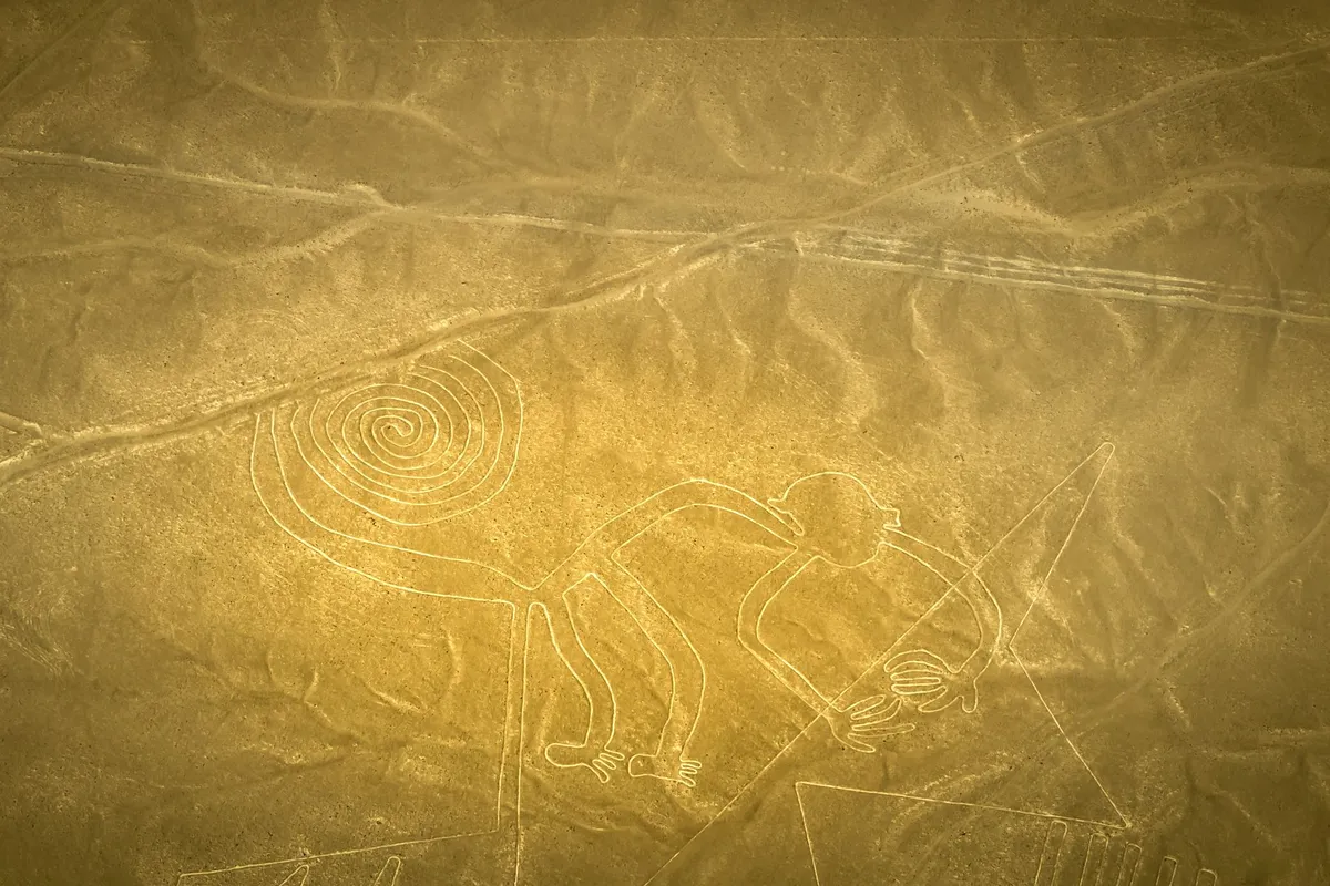
UNESCO reports that the geoglyphs of Nasca and Palpa spread across about 450 km² of arid coastal plain, roughly 400 kilometers south of Lima. The figures were drawn, broadly speaking, between 500 BC and 500 AD, with phases associated with the Paracas and Nasca traditions. The site was added to the World Heritage List in 1994.
How the geoglyphs were made
The technique is less mysterious than the scale of the result. The creators removed the surface layer of stones darkened by exposure to the elements, revealing lighter soil beneath. This produced outlines that contrast with the pampa. No deep trenches were needed, nor any vanished material: the difference in the ground’s color itself formed the drawings.
Some figures represent recognizable animals, such as a monkey, spider, hummingbird and condor; others are lines several kilometers long, triangles, spirals and abstract shapes. This variety shows that the activity did not happen all at once. There were many interventions, overlaps and choices of scale over an extensive period.
What is the mystery of the Nazca Lines
The main mystery is the exact purpose of the ensemble: why so many lines and figures were created and how each group used them. The interpretation accepted by UNESCO points to a symbolic and ritual landscape, possibly linked to astronomy, religion, water and social organization. That is different from saying there is a single proven explanation.
Extraterrestrial hypotheses are part of popular culture, but they are not needed to explain the construction. The Paracas and Nasca societies had knowledge of the terrain, collective organization and time to plan large-scale tracings. The fact that a figure is best perceived from above does not prove that its makers needed to fly: long lines can be laid out on the ground using reference points, ropes, stakes and proportional scaling.
Why the Nazca Lines don’t fade
The lines have endured because the region combines extreme aridity, very rare rainfall and little surface water activity. UNESCO explains that these conditions favored their preservation for nearly two millennia. The displaced gravel also left a stable contrast between the dark surface and the exposed light soil.
That doesn’t mean they are indestructible. Roads, off-route vehicles, irregular occupation and weather events can cause damage. The Pan-American Highway South crosses part of the archaeological area and has already affected some sectors. That’s why observing from authorized locations and not walking on the tracings is a preservation rule, not just a tourist recommendation.
How to see the Nazca Lines: flight or viewing tower
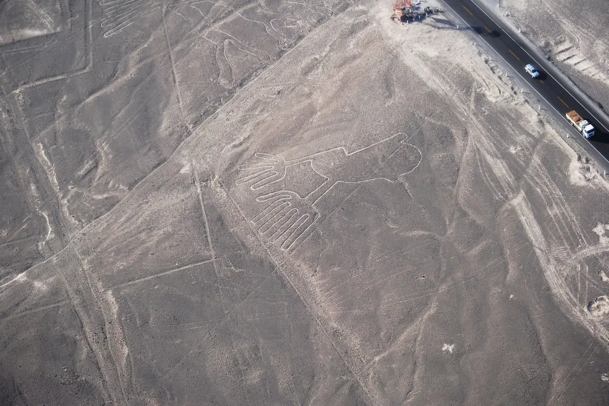
The flight delivers the broadest and most recognizable view of the figures; the viewing tower requires less effort, avoids the flight and shows a smaller portion of the site. The choice depends on budget, sensitivity to motion, available time and archaeological interest.
| Option | What you see | When it’s worth it | Main limitation |
|---|---|---|---|
| Flight | Several figures, lines and the scale of the pampa | First visit and strong interest in the site | Higher price and turns that can cause motion sickness |
| Viewing tower | A few geoglyphs near the road | Smaller budget, little time or fear of flying | Restricted field of view |
| Museum + viewing tower | Historical context and land-based observation | Those who value María Reiche’s research | Doesn’t replace the scale revealed from above |
Flight: the most complete experience
An operational program published for 2026 states about 30 minutes of flight over the main figures, though total time includes transfer, check-in, weighing, instructions and possible waits for weather conditions. Book the morning in Nazca, because changes in visibility or flight order can push your time slot back.
Small aircraft tilt to both sides to give passengers a view. If you’re prone to motion sickness, eat a light meal, avoid alcohol the night before and talk to a healthcare professional about measures suited to your case. Also confirm weight policy, required documents, local fees, aircraft model and operator certification before paying.
Where to stay in Huacachina
| Hotel | Rating | |
|---|---|---|
| Senoma Hotel - Adults onlyHuacachina (oasis) · Adults only, on Av. Ángela Perotti, in the oasis | 8,9935 reviews | See prices |
| Huacachina Desert HouseHuacachina entrance · In Urb. La Estancia de Huacachina, with a pool | 8,5616 reviews | See prices |
| La Estancia Hotel IcaHuacachina entrance · In La Rinconada de Huacachina, with free bicycles | 8,0197 reviews | See prices |
| Hotel Las DunasLa Angostura (Ica) · Resort with 3 pools and a spa on Av. La Angostura | 9,0675 reviews | See prices |
| DEL VALLE HOUSE IILa Angostura (Ica) · In Residencial La Angostura, with a pool | 8,9138 reviews | See prices |
| Serenity LodgeIca city centre · In the city of Ica, with a pool and transfer | 8,4371 reviews | See prices |
Booking.com rating on 30/09/2026
Viewing tower: a land-based alternative, not a miniature of the flight
The official viewing tower stands at kilometer 424 of the Pan-American Highway South, according to the Ministry of Culture of Peru. It allows you to observe nearby geoglyphs without entering the protected area. The experience is short and to the point, but it doesn’t offer the variety of drawings or the spatial sense of the flight.
Combining the viewing tower with the María Reiche Museum improves the visit, because the researcher’s work helps you understand surveying, conservation and interpretation. This combination is especially good for those who don’t want to fly. Check updated opening hours before setting out: the road is long, and arriving after closing reduces the stop to an exterior view.
 Partner · Civitatissee all activities in Huacachina ›
- Sandboarding in the Ica Desert at SunsetRating 7.7 · 21 reviews on Civitatisfrom€18.10per personSee ›
- Night in the Ica DesertRating 10 · 1 reviews on Civitatisfrom€281.94per personSee ›
- Huacachina Instagram TourRating 10 · 2 reviews on Civitatisfrom€31.03per personSee ›
- Ica Desert Sandboarding or Sand Skiing Classfrom€46.55per personSee ›
Civitatis prices on 28/09/2026, from, per person. They may change.
If the budget allows and small flights aren’t a problem, the flight is the most coherent decision for a first visit. If cost, motion sickness or fear weigh more heavily, the museum and viewing tower deliver an honest reading of the place without selling the impression that you’ll see the entire ensemble.
What to do in Ica beyond heading to Nazca
Ica deserves at least a day, as it brings together an oasis, dunes, regional history and pisco production; the city works better as a stop with choices than as a simple bus terminal. The contrast between desert and irrigated valley explains much of the local identity.
Huacachina and the dunes
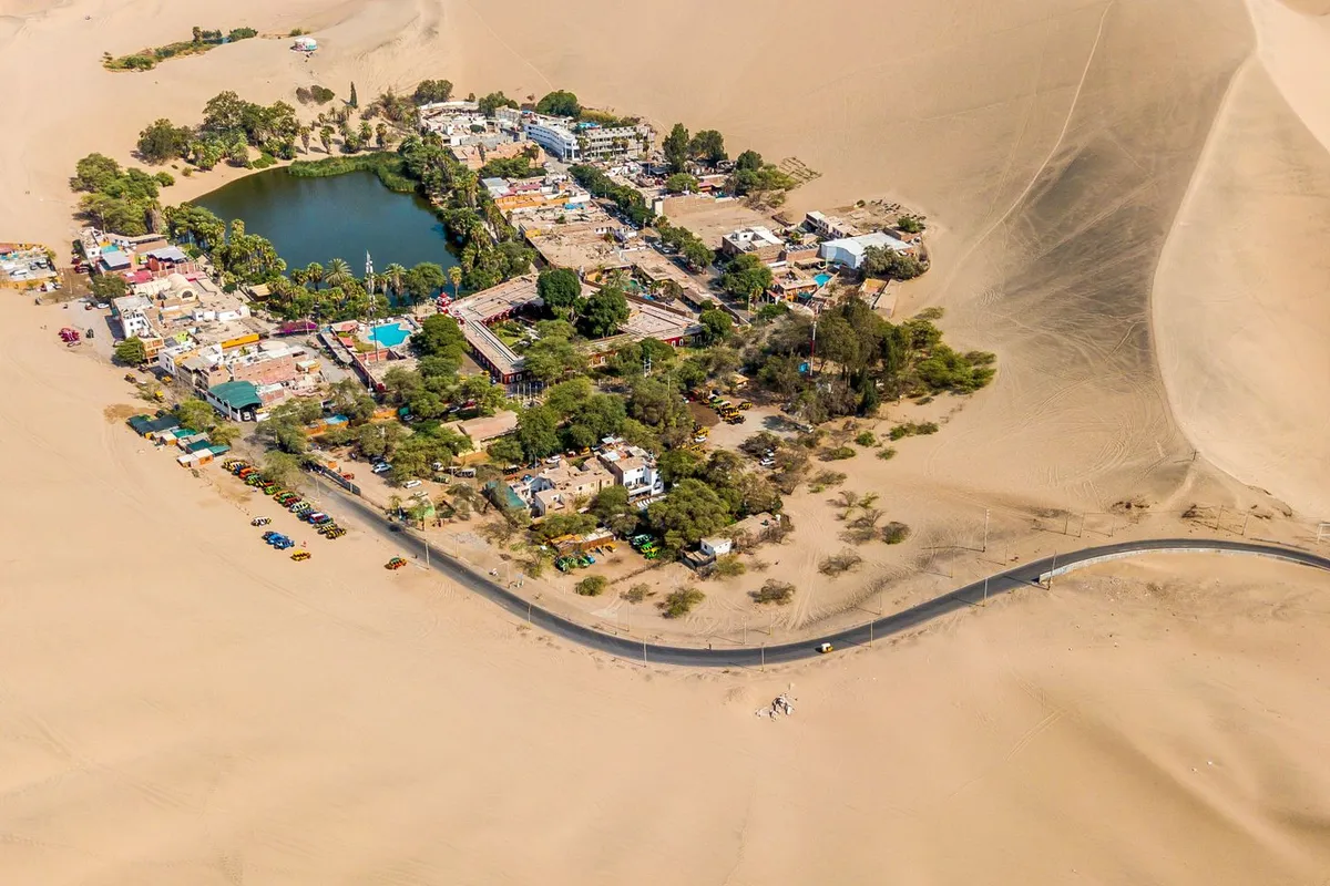
Huacachina is Ica’s best-known image: a lagoon surrounded by palm trees, lodgings and tall dunes. The village is compact, but what changes the experience are the desert activities. Buggy rides and sandboarding usually aim for late-afternoon light; confirm duration, equipment, insurance and meeting point.
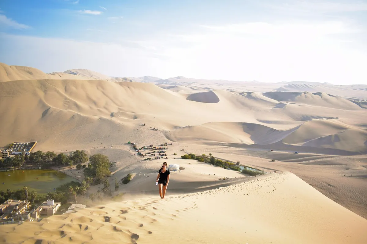
Climbing a dune on foot offers a view of the oasis without depending on a vehicle, but soft sand, sun and incline make the effort greater than the distance suggests. Bring water, sun protection and footwear that can take on sand. Avoid walking in the peak heat and don’t count on shade outside the village.
Pisco, vineyards and regional history
The irrigated valleys around Ica sustain grapes and the pisco tradition, creating a direct contrast with the dunes. A visit to a bodega makes sense for those who want to understand fermentation and distillation, but compare tasting, transport and duration. Whoever is driving shouldn’t drink; hiring a transfer solves a decision that is often left to the last minute.
For archaeological context, regional museums help connect Paracas and Nasca before you reach the geoglyphs. This order makes the visit less dependent on “mysteries” and more connected to the societies that occupied the southern coast. If the day is short, prioritize one desert experience and one context experience — trying to fit in the oasis, a bodega, a museum and the trip to Nazca tends to produce a rushed sequence.
3-day itinerary through Ica and Nazca
Set aside 3 days to combine Ica, Huacachina and Nazca: one day for the valley and the dunes, another for the journey with context and a third for the lines. Two days are possible, but they require cutting attractions and accepting little margin for delays.
Day 1: Ica and sunset over the dunes
Leave Lima early and use the first half of the day to arrive, drop off your luggage and have a leisurely lunch. In the afternoon, choose between a short visit to a bodega or museum and head to Huacachina. Save the end of the day for the dunes, when the temperature is usually more tolerable and the light better defines the terrain.
Day 2: Ica context and travel to Nazca
Use the morning for the attraction you missed on the first day. Then make the journey to Nazca with a buffer and arrive before nightfall. Sleeping in the city matters: you avoid leaving Ica at dawn, arrive rested at the airfield and keep flexibility if the flight depends on visibility.
Those who opted only for the viewing tower can fit it into the journey, as long as they confirm access and hours. Even so, it’s worth sleeping in Nazca if there’s a museum or archaeological site the next day. Saving all the travel for a single journey increases the chance of missing a booking due to road delays.
Day 3: flight or viewing tower and continuing the trip
Schedule the main activity for the morning and keep the rest of the day flexible. After the flight, wait for your body to settle before a heavy meal or another winding road. Those who chose the land route can combine museum, viewing tower and a nearby archaeological attraction, respecting the real time between points.
When you finish, head to Arequipa on a night bus only if the comfort of the service allows rest; otherwise, an extra night in Nazca is a better decision than arriving exhausted in the next city. To return to Lima, compare daytime and nighttime schedules and don’t book an international flight on the same day as a long bus journey.
Is it hard to breathe in Ica and Nazca?
In Ica and Nazca, altitude doesn’t usually cause the breathing discomfort associated with the Andes: Ica sits at just 406 meters, right on the desert coast. People with heart or respiratory conditions may have their own limitations, but the circuit doesn’t require the acclimatization needed in very high cities.
The question “is it hard to breathe in Peru?” has no single answer because the country ranges from sea level to high Andean altitudes. Lima, Ica and Nazca belong to the low coastal strip; Cusco, Puno and mountain stretches present a different reality. If your itinerary continues into the Andes, organize your adaptation with our guide to acclimatization and your first days in Cusco.
In the desert, the most likely discomfort is different: heat, dry air, dust, wind and dehydration. Drink water regularly, use sunscreen, sunglasses and head covering. In case of intense shortness of breath, chest pain, confusion or fainting, seek medical attention; don’t automatically attribute the symptom to the climate.
 HotelAs soon as you have datesCompare neighbourhoods and guest ratings.Booking ›
- ActivitiesBefore you travelBook ahead the ones with limited spots.Civitatis ›
Frequently asked questions about Ica and Nazca
The short answers below clarify common names and comparisons without replacing the practical decisions of access, duration and how to observe the lines.
What does Nazca mean?
Nasca is the name used for the archaeological culture, the city and the province; “Nazca” is the spelling widely used in Portuguese and in tourism. UNESCO adopted “Nasca” in the official name of the heritage site. Reducing the term to a literal translation is risky, because the etymological origin has no single consensus interpretation in the sources consulted.
What is the most famous desert in Peru?
There is no official title of “most famous desert.” The Nazca pampa is world-renowned for its geoglyphs, while Huacachina represents the most recognizable dune landscape for many travelers. The Sechura Desert is a broader geographic reference in the north of the country. For this itinerary, what matters is distinguishing the Nazca archaeological area from the leisure dunes in Ica.
What is the most beautiful city in Peru?
Beauty is a subjective comparison: Arequipa tends to attract for its volcanic stone architecture, Cusco for its Andean historic ensemble and Lima for its coast and urban neighborhoods. Ica doesn’t compete mainly on monumental architecture; its value lies in the meeting of valley, pisco, oasis and desert. Nazca, in turn, is a functional base for a heritage site that extends beyond the urban area.
Is it worth doing Ica and Nazca in a single day?
It’s not the best choice. The journey from Lima, the visit to the dunes and the observation of the lines make for too long a day, with little margin for traffic or schedule changes. If you only have one day, choose Ica and Huacachina or go directly to Nazca for the main activity. With three days, the circuit stops being a race and gains time for context, rest and safe decisions.
Before booking, confirm bus schedules, flight conditions, viewing tower opening hours and baggage policy on the operators’ pages. This data changes; the structure of the itinerary should keep a buffer so that one change doesn’t bring down the whole trip.
If the absolute priority is the Nazca Lines, sleep in the city the night before and book the following morning. If the priority is the dunes, focus your first night in Ica and don’t force the journey after sunset. This simple choice defines a much more comfortable circuit.
The next step is deciding between the flight and the viewing tower. Once that choice is made, bus schedules and lodging nights fall into place clearly — and the desert stops being just a backdrop to become the logic of the entire route.