 Marcelo Oliveira
If you typed “Urubici” into Google thinking you’d find just a chilly little town in Santa Catarina, the first surprise is the sheer size of the attraction list: two mountain roads (Rio do Rastro and Corvo Branco), Pedra Furada at 1,822 m of altitude, and more than ten waterfalls and canyons within a 30 km radius. Urubici, in Santa Catarina, is the ideal base for exploring the Serra Catarinense — the high-altitude region of southern Brazil where the thermometer plunges in winter and the landscapes look like Patagonia.
Hotels in Urubicifree cancellation options onlySee hotels ›Booking.com partner (advertising): we may earn a commission at no extra cost to you.
Urubici is 200 km from Florianópolis, about 3h30 by car along the BR-282, and it’s the base for visiting Serra do Rio do Rastro, Serra do Corvo Branco, Pedra Furada, and waterfalls like Avencal. The ideal is 4 full days to cover the main attractions of the Serra Catarinense without rushing, with park tickets ranging from R$ 10 to R$ 80 per attraction (Sep/2025).
| Distance from Florianópolis | 200 km via BR-282 (Alfredo Wagner and Bom Retiro), about 3h30 by car (Sep/2025) — RotaMapas |
|---|---|
| How long to stay | 4 full days to see the main attractions at a relaxed pace (seasonal winter itinerary) |
| Pedra Furada / Morro da Igreja | Free, but requires prior authorization through the ICMBio website + pickup in Urubici (8am-12pm and 2pm-4pm) |
| Cascata do Avencal | R$ 50 per person, 8am-5:30pm every day (Sep/2025) |
| Serra do Corvo Branco (viewpoint) | Free road; the glass viewpoints at Altos do Corvo Branco cost R$ 80 (Sep/2025) |
| How to get there | Your own car or app/van from Florianópolis; there’s no direct regular public transportation |
How to get to Urubici from Florianópolis and other cities
Urubici is 200 km from Florianópolis, a trip of roughly 3h30 by car along the BR-282, passing through Alfredo Wagner and Bom Retiro (Sep/2025). It’s the most-used route for those arriving at Florianópolis airport (Hercílio Luz), the closest one with regular flights. There’s no direct regular public transportation between the capital and the town — the trip is made by your own car, a long-distance app, or vans from tour operators that leave Floripa on specific days.
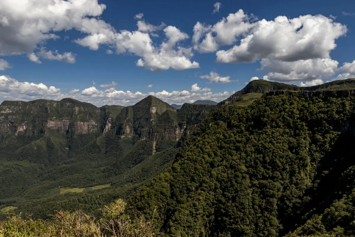
Those coming from Curitiba face about 280 km (4h) via BR-116 and then state roads; from Porto Alegre, the distance climbs to over 400 km. On any route, the final stretch into Urubici has mountains and curves — avoid arriving at dawn or in heavy rain, common in July and August. A car with good grip and checked brakes makes a difference, since part of the tour around the region (Serra do Corvo Branco, access to canyons) is on dirt or stone roads.
The best time to visit Urubici and how long to stay
The best time to visit Urubici is between May and September, in autumn and winter, when the weather turns dry, the sky tends to clear more (less cloud cover), and there’s a real chance of frost or snow on the coldest days. To really get to know the town and the surrounding mountains, the ideal is 4 full days — enough time to split between waterfalls, viewpoints, and the two mountain roads without rushing.
Urubici doesn’t snow every winter, but it’s one of the Brazilian towns with the most records of snow and frost thanks to its altitude (the town center sits at about 900 m, and spots like Pedra Furada exceed 1,800 m). When it happens, snow tends to concentrate between June and August, during the most intense cold fronts — it’s worth following short-term forecasts rather than planning the trip based only on that, because there’s no guarantee. Those seeking this high-altitude climate in Brazil also often compare Urubici with nature destinations like Chapada dos Veadeiros, listed among the best nature destinations in Brazil.
| Period | Weather | Best for |
|---|---|---|
| May to September (autumn/winter) | Intense cold, dry, chance of frost/snow | Winter scenery, sunrise photos, cold-weather lovers |
| October to December (spring) | Mild temperatures, full waterfalls | Trails and waterfalls without extreme cold |
| January to March (summer) | Warmer days, still-cool nights | Those escaping the coastal heat |
The mountains of Urubici: Serra do Rio do Rastro and Serra do Corvo Branco
Urubici gives access to two of Brazil’s most famous mountain roads: Serra do Rio do Rastro, with 284 curves and a drop of about 1,460 m between the plateau and the coast, and Serra do Corvo Branco, which cuts through the rock in a wall roughly 90 meters high — said to be the largest rock cut in the country. Both are less than an hour’s drive from downtown Urubici and are usually visited on separate days.
Serra do Corvo Branco is free to drive, but the Altos do Corvo Branco complex, with glass viewpoints suspended over the valley, charges R$ 80 per person (Sep/2025). Serra do Rio do Rastro, meanwhile, has free access and an official viewpoint at the top, from where you can see the winding road descending toward the southern Santa Catarina coast — especially popular with motorcycle travelers.
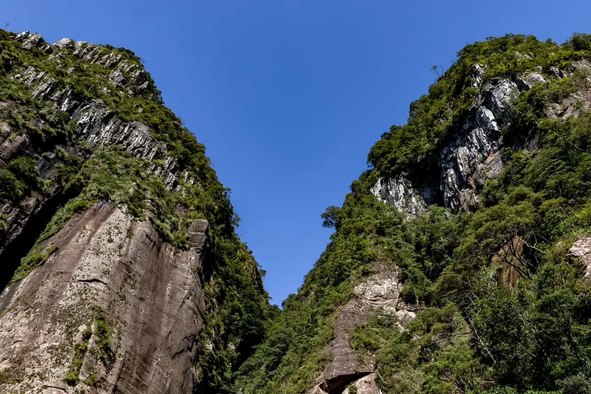
Serra do Rio do Rastro and Serra do Corvo Branco are not the same road: they’re in different municipalities (the first connects Bom Jardim da Serra to Lauro Müller; the second connects Urubici to Grão-Pará) and have distinct geological formations — one is famous for its curves, the other for its vertical rock cut. Those with only one day available usually choose Serra do Corvo Branco because it’s closer to downtown Urubici.
Pedra Furada and Morro da Igreja: what they are and how to visit
Pedra Furada is a rock formation with a natural opening of about 13 by 6 meters, at the top of Morro da Igreja, inside São Joaquim National Park — at roughly 1,822 m of altitude, one of the highest points in southern Brazil. The visit is free, but requires prior authorization obtained through the ICMBio visitor guide for São Joaquim National Park, picked up in person in Urubici during business hours (8am-12pm and 2pm-4pm, Sep/2025).
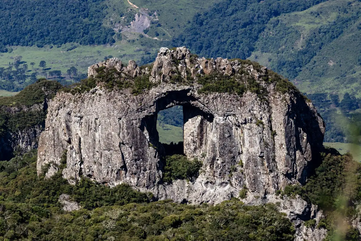
Bring cold-weather clothing even on sunny days — the wind at the top is usually strong and the wind chill drops considerably compared to downtown. The final stretch to the Pedra Furada viewpoint is short and partly paved, but access to the park itself is via a dirt road, which can get slippery on rainy or frosty days.
The best waterfalls in Urubici (Avencal, Papuã, Rio dos Bugres)
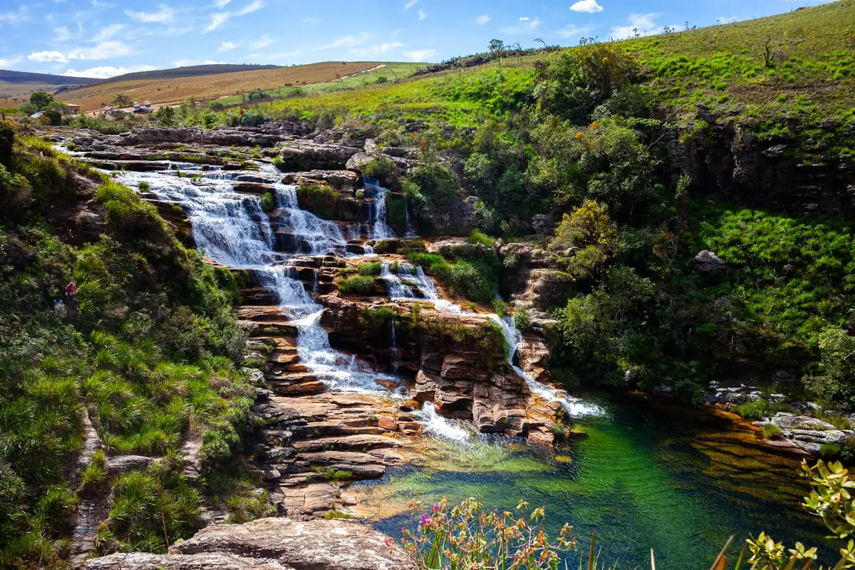
Urubici has more waterfalls than any visitor could see in a single trip: Cascata do Avencal drops 100 meters inside Mundo Novo Park, Cachoeira Papuã has suspended walkways and a glass viewpoint 120 m high, and Cachoeira do Rio dos Bugres, at about 220 meters, is considered the tallest waterfall in town.
| Cascata do Avencal | R$ 50 per person, access from above and below, 8am-5:30pm (Sep/2025) |
|---|---|
| Cachoeira Papuã | R$ 60 per person, with a Sky Bike option, 8:30am-5:30pm every day (Sep/2025) |
| Cachoeira do Rio dos Bugres | R$ 30 per person; camping on site for R$ 50 (Sep/2025) |
| Cânion Espraiado | R$ 30 per person; access by 4×4 or on foot (Sep/2025) |
| Sítio Sete Quedas | R$ 25 per person; usually closed in winter (Sep/2025) |
| Morro do Campestre | R$ 40 per person, view of the Canoas River Valley (Sep/2025) |
| Gruta Nossa Senhora de Lourdes | R$ 10 per person (Sep/2025) |
With 4 days, you can fit 2 to 3 of these attractions per day without rushing, since most are 15-40 minutes from downtown along dirt roads. Add ticket + fuel/transport and the “real total cost” of a day with two waterfalls comes to between R$ 100 and R$ 160 per person (Sep/2025), considering a rental car or fuel for your own car split among the group.
What to combine with your visit to Urubici
Beyond the mountains, Pedra Furada, and the waterfalls, Urubici is close to São Joaquim National Park (free entry, open daily from 8am to 5pm, Sep/2025), which is home to centuries-old araucaria trees and is another strong spot for observing snow and frost in winter. High-altitude wineries, like Vinícola Serra do Sol, and the Eco Parque Cascata Véu de Noiva also fit well into a 4-day itinerary, especially on the third or fourth day, when the pace can be more relaxed.
Those with more time available often wrap up the trip at the beach, since the Santa Catarina coast is just a few hours from the mountains: Praia do Rosa and the Balneário Camboriú, Bombinhas, and Itajaí area are the most common add-ons for those heading down from the mountains toward the sea.
Those entering or leaving through Florianópolis can use the stopover to explore the capital’s beaches before heading up to the mountains — it’s worth booking the Florianópolis beaches tour in Portuguese if your itinerary includes a day or two in the capital.
Where to eat in Urubici
The town is small, but it’s a hub for the mountain cuisine of Santa Catarina: roasted pinhão (in season from April to July), fondue on cold nights, cheeses and cured meats from local producers, and dishes with trout, farmed in the region’s own fish ponds. Restaurants and cafés are mostly in the central area and along the access roads to the waterfalls, many operating by reservation in low season.
On weekdays outside winter, it’s common to find places closing earlier or operating only with prior reservation — it’s worth confirming by phone or WhatsApp before heading out, especially at night. The Urubici city government usually publishes seasonal notices about the operation of businesses and attractions on low-traffic dates.
Where to stay in Urubici
Urubici is full of inns and chalets geared toward the mountain climate, with fireplaces and a cozy atmosphere as a highlight. Rates vary widely: simpler inns start at affordable prices, while chalets with mountain views and their own fireplace fall in the higher range — it’s worth comparing on accommodation search engines at the time of booking, since prices change by season. Booking in advance is recommended for July and for weekends with a possible snow forecast, when occupancy rises quickly.
Where to stay in Urubici
| Hotel | Rating | |
|---|---|---|
| Hospedagem Família CruzSC-370 · SC-370, km 82 | 9,8239 reviews | See prices |
| Pousada Encanto do AvencalAvencal · Near Cascata do Avencal | 9,5362 reviews | See prices |
| Pousada Flor do CampestreCampestre · Estrada Geral SC-370, Campestre | 9,3392 reviews | See prices |
| Refúgio da MontanhaÁguas Brancas · Estrada Geral Águas Brancas, 270 | 9,3259 reviews | See prices |
| Café e Cabanas Lenha no FogoSanta Terezinha · Estrada Geral Santa Terezinha, SC-370 | 9,1423 reviews | See prices |
| Cabanas Cold MountainÁguas Brancas · SC-110, Águas Brancas | 9,1366 reviews | See prices |
| Pousada UpSerraCity centre · Av. Adolfo Konder, 2273 | 8,91.212 reviews | See prices |
| Pousada Jardim do BudaAvencal · Lower part of Cascata do Avencal | 8,1493 reviews | See prices |
Booking.com rating on 30/09/2026
Practical tips and what nobody tells you before going to Urubici
Urubici is worth it for anyone who loves high-altitude scenery, real cold, and a road-trip itinerary — but the destination has quirks that go beyond the obvious beach or historic town, so it’s worth preparing:
- Bring cold-weather clothing in layers even in summer: the temperature difference between downtown and the viewpoints above 1,400 m can exceed 10°C.
- Most attractions (waterfalls, canyons, hills) are private property with a visitation fee charged on site — bring cash or check whether they accept cards before going, because internet connection is unstable in these areas.
- Pedra Furada requires advance booking through ICMBio; many people arrive without a reservation and can’t go up the same day.
- Dirt roads to some waterfalls and to Cânion Espraiado get much worse on rainy days — a low car may struggle.
- Sítio Sete Quedas usually closes during winter (the season most sought after by tourists), so confirm it’s open before adding it to your itinerary.
- Cell signal is weak or nonexistent on several stretches between attractions — download offline maps before you set out.
For those with only 1 day or traveling with children, the most feasible option is to combine Serra do Corvo Branco (free viewpoint, straight from the car) with an easier-access waterfall, like Cascata do Avencal, which has a short trail to the upper viewpoint.
 HotelAs soon as you have datesCompare neighbourhoods and guest ratings.See hotels ↑
 ActivitiesBefore you travelBook ahead the ones with limited spots.Civitatis ›
Frequently asked questions
Where is Urubici in Santa Catarina?
Urubici is in the Serra Catarinense, a mountain region in the center-south of Santa Catarina, about 200 km from Florianópolis and just a few kilometers from São Joaquim National Park.
How many km from Florianópolis to Urubici and how long by car?
It’s about 200 km between Florianópolis and Urubici along the BR-282, with an average travel time of 3h30 by car under normal traffic and weather conditions (Sep/2025).
Do you need to book to see Pedra Furada?
Yes. Access to Morro da Igreja and Pedra Furada, inside São Joaquim National Park, requires prior authorization obtained on the ICMBio website and picked up in person in Urubici during business hours (Sep/2025).
Does it snow a lot in Urubici? When is snow most likely?
Urubici doesn’t snow every year, but it’s among the Brazilian towns with the most records of snow and frost thanks to its altitude. When it happens, it’s usually between June and August, during the most intense cold fronts — with no guarantee, since it depends on each year’s weather.
Are Serra do Rio do Rastro and Serra do Corvo Branco the same thing?
No. They’re two different mountain roads, in different municipalities: Serra do Rio do Rastro connects Bom Jardim da Serra to Lauro Müller and is famous for its curves; Serra do Corvo Branco connects Urubici to Grão-Pará and is famous for its vertical rock cut.
Conclusion
Urubici works best as a base for exploring the entire Serra Catarinense: you can sleep in town and, in 4 days, cover both mountain ranges, Pedra Furada, and the main waterfalls without rushing. If you’ve already decided to include this itinerary in your trip through Santa Catarina, Voyage Voyage is preparing dedicated guides for each attraction — Serra do Rio do Rastro, Serra do Corvo Branco, Pedra Furada, and Cascata do Avencal — to help you plan each stage in more detail.